| Research Publications Projects Curriculum Links Home |
1. The lithospheric structure of the Gorringe Bank: insights into its origin and tectonic evolution(pdf) |
|
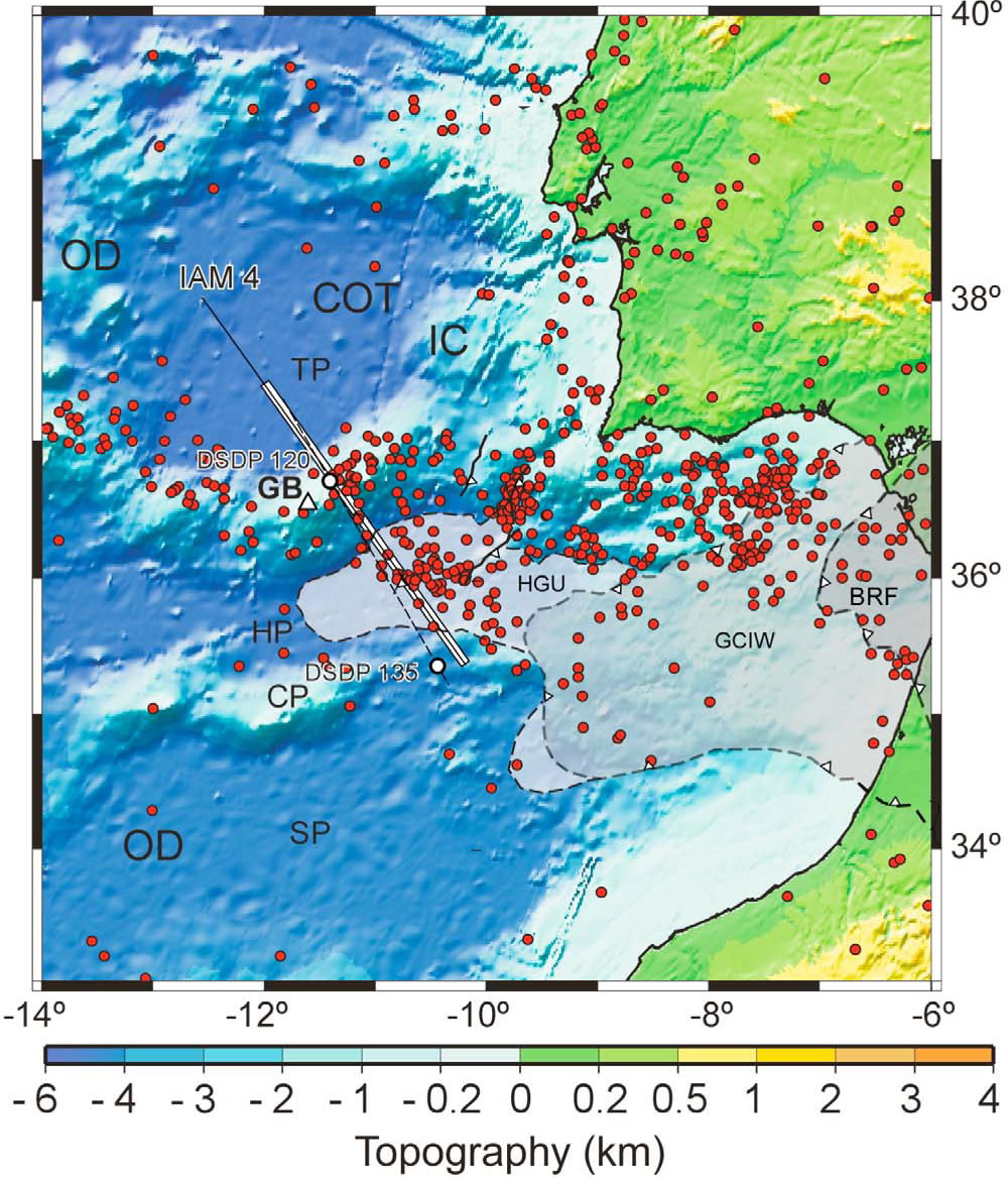
The Gorringe Bank is a 5000 m-height seamount near the Atlantic coast of Iberia characterized by a 9-m-height geoid anomaly and a ~120 mGal Bouguer anomaly relative to the surrounding abyssal plains. It has been related to a NW-directed thrust carrying exhumed upper mantle rocks and transitional crust on top of flexed-down Eurasian oceanic crust along the Tagus Abyssal Plain. However, estimations of crustal shortening yielded dissimilar results and the deep structure of the ridge remains highly unknown. Topography of the study region with localization of deep seismic profiles (IAM-4 as solid line [Banda et al., 1995], and AR92-3 as dashed line [Sartori et al., 1994]) and our modeled transect (open white box). The modeled profile is in the NW-SE direction, from Tagus Abyssal Plain (TP) crossing the Gorringe Bank (GB) and Horseshoe Abyssal Plain (HP). |
|
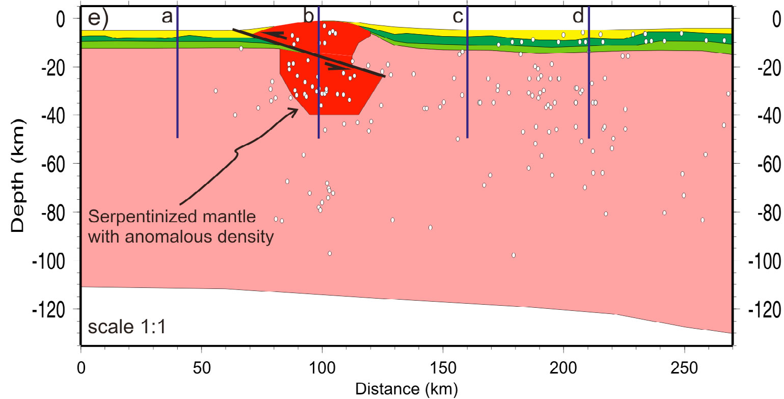
We present a restored cross-section and a new model of lithospheric structure based on gravity, geoid, elevation, and the presence of serpentinized peridotites. At least 20 km of shortening took place along a flat-ramp-flat thrust fault, and the density structure of the lithosphere is consistent with mantle serpentinization varying from 70% at surface to 20% at 14 km depth, and 0% at 40 km. The topographic relief and the gravity anomalies are explained by assuming a flexural isostatic model with a Te~30km.
|
|
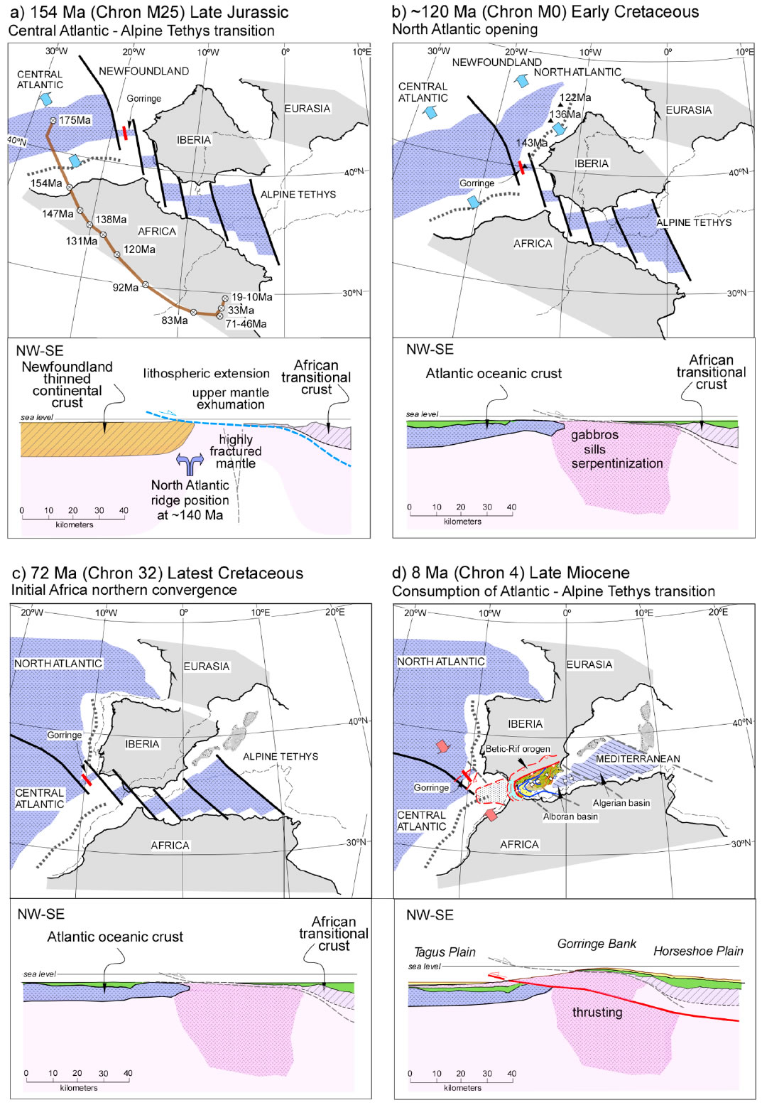
The evolution of the Gorringe Bank since the Late Jurassic is interpreted in relation to the Eurasia-Africa-North America plate motion in four stages: 1) transtension between Newfoundland-Iberia and Africa generating small oceanic basins and mantle exhumation; 2) opening of the North Atlantic and sea-floor spreading at the NW side of the exhumed Gorringe producing gabbro intrusions and serpentinization; 3) quiescent tectonic period dominated by subsidence and sediment accumulation, and 4) transpressional plate boundary between Eurasia and Africa with NW-directed subcrustal thrusting and generation of the present Gorringe relief.
More details on the paper (pdf)
|
|
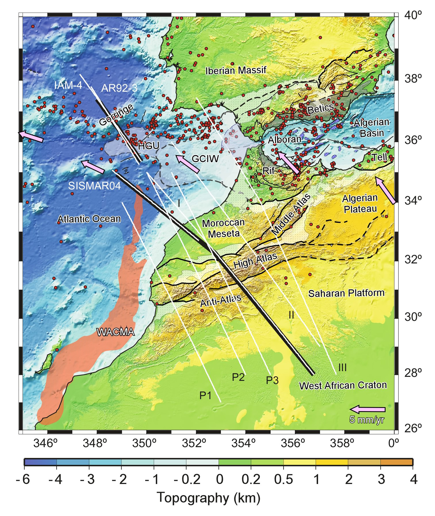
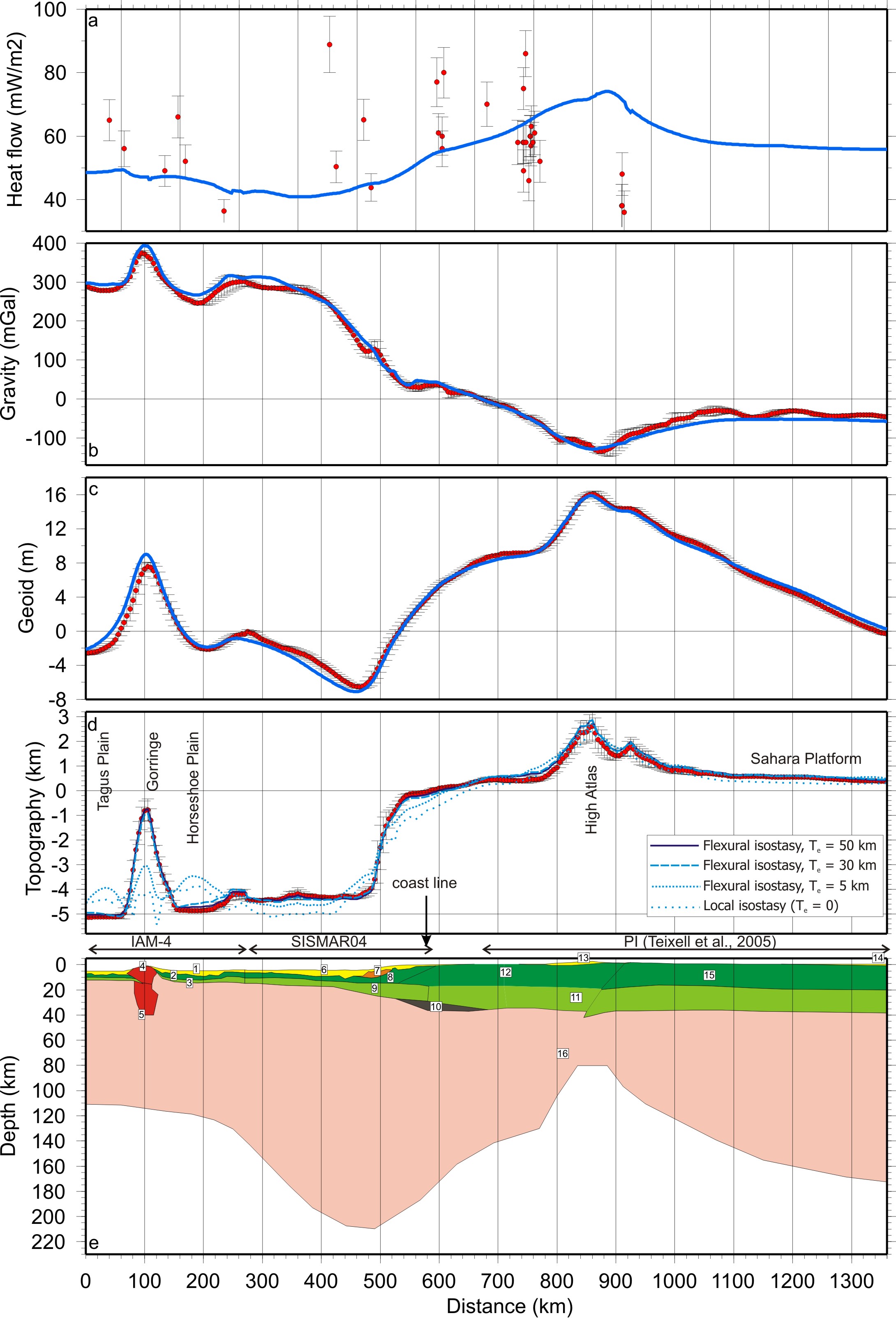
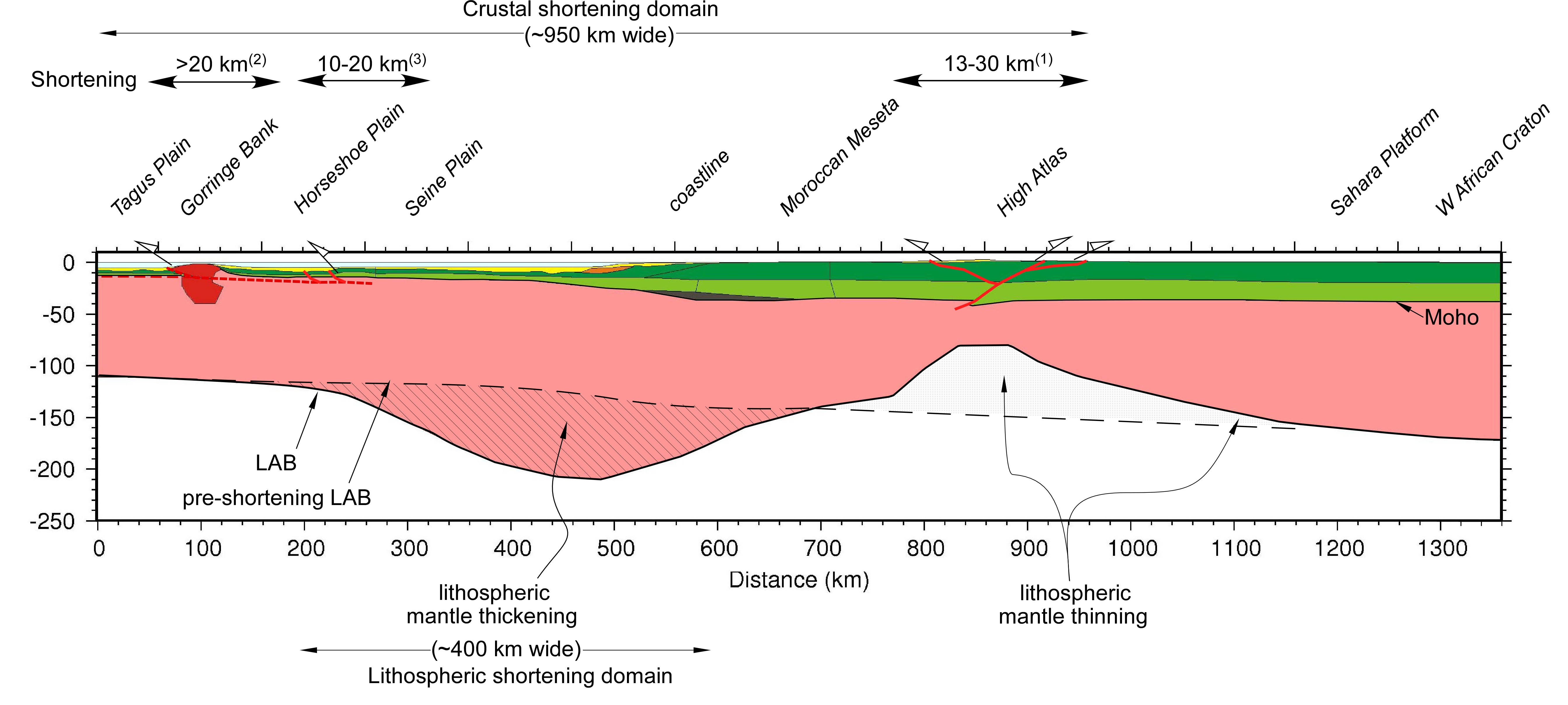
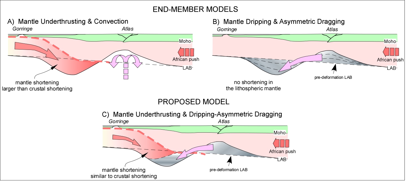
2. Decoupled crust-mantle accommodation of Africa-Eurasia convergence in the NW Moroccan margin(pdf) The extent of the area accommodating convergence between the African and Iberian plates, how this convergence is partitioned between crust and mantle and which is the role of the plate boundary in accommodating deformation are not well understood subjects. We calculate the structure of the lithosphere derived from its density distribution along a profile running from the Tagus Abyssal Plain to the Sahara Platform and crossing the Gorringe Bank, the NW Moroccan Margin and the Atlas Mountains. The model is based on the integration of gravity, geoid, elevation and heat flow data and on the crustal structure across the NW Moroccan Margin derived from reflection and wide-angle seismic data. The resulting mantle density anomalies suggest important variations of the LAB (lithosphere-asthenosphere boundary) topography indicating a prominent lithospheric mantle thickening beneath the margin (LAB >200 km-depth) followed by thinning beneath the Atlas Mountains (LAB ~90 km-depth). At crustal levels, the Iberia-Africa convergence is sparsely accommodated in a ~950 km wide area and localized in the Atlas and Gorringe regions, with an inferred shortening of ~50 km. In contrast, mantle thickening accommodates in a 400 km wide region, thus advocating for a decoupled crustal-mantle mechanical response. A combination of mantle underthrusting due to oblique convergence together with a viscous dripping fed by lateral mantle dragging can explain the imaged lithospheric structure. The model is consistent with crustal shortening estimates and with the accommodation of part of the Iberia-Africa convergence farther NW of the Gorringe Bank and/or off the strike of the profile.
|
|
|
|
|
Model results (blue lines) and measured data with the standard deviation indicating lateral variability of data projected into the profile from a strip of 25 km half-width (red dots and vertical bars): a) Surface heat flow projected band 100 km and ±10% uncertainty, b) Bouguer anomaly, c) Geoid, d) elevation, and e) lithosphere structure. Line patterns in panel d) indicate different elastic thickness values used to isostatically compensate the lithospheric structure shown in e). Numbers in panel e) represent the different materials described in Table 1.
Schematic lithospheric cross-section showing the crustal and lithospheric mantle shortening domains. Black dashed line shows the assumed pre-shortening LAB depth.
Cartoon showing the end-member models to explain lithosphere mantle thickening and adjacent thinning: a) mantle underthrusting related to plate convergence and thermal erosion produced by convection or mantle plume and b) lateral displacement of mantle material related to mantle dripping and dragging. c) Preferred model for the NW-Moroccan margin: underthrusting related to similar amount of crustal shortening plus lateral displacement of all the material missing beneath the Atlas due to dripping and lateral dragging.
More details on the paper (pdf)
|
|
|
|