The Tibetan Plateau is the product of crustal thickening
caused by collision between India and Asia. Plate tectonic reconstructions
suggest continuous northward movement of the Indian plate relative
to stable Eurasia at nearly 50 mm/yr for the last 50 My. The plateau
is now at ~5 km elevation with steep topographic gradients across
the southern and northern margins. These gradients are also associated
with large lateral variations in geoid and gravity anomalies. Uplift
late in the tectonic evolution of the plateau, the widespread extension,
and the associated magmatism have been attributed to removal of
the lower part of lithospheric mantle and its replacement by hotter
and lighter asthenosphere.
Here we present a two-dimensional lithospheric thermal
and density model of the present day structure and numerical modeling
of the evolution of the Tibetan Plateau:
- The two-dimensional lithospheric model is along a transect from
the Indian plate to Asia, crossing the Himalaya front and the Tibetan
Plateau. The model is based on the assumption of local isostatic
equilibrium, and is constrained by the topography, gravity and geoid
anomalies and by thermal data within the crust. Our results suggest
that the height of the Tibetan Plateau is compensated by thick crust
in the south and by hot upper mantle to the north. The Tibetan Plateau
as a whole cannot be supported isostatically only by thickened crust;
a thin and hot lithosphere beneath the northern Plateau is required
to explain the high topography, gravity, geoid and crustal temperatures.
- We also investigate numerically the long-term (50 My) evolution
of crustal and lithospheric thickness, thermal structure, topography,
and strain-rate of the Tibetan plateau through time, using a planform
viscous approach. This suggests that lithospheric mantle must have
been removed from beneath Tibet, and that the crust must have been
warmed and weakened by an increase of radiogenic heat production
at depth due to crustal thickening. |
1. Influence of mantle dynamics on the topographic evolution of the Tibetan Plateau: Results from numerical modelling
(Publication: pdf)
We investigate numerically the evolution of crustal
and lithospheric thickness, thermal structure, topography, and strain-rate
of the Tibetan plateau through time, using the thin viscous sheet
approach. We show that lithospheric mantle must have been removed
from beneath Tibet to explain the present surface elevation and
lack of regional surface slope. In the absence of this removal,
the modelled topography reaches a maximum elevation of <4000
m (for weak rheology), or the surface slopes significantly northwards
(for strong rheology). The crust must have been warmed and weakened
by an increase of radiogenic heat production at depth due to crustal
thickening. In the absence of this warming, viscous stresses associated
with plate convergence exceed stresses produced by topography, and
the present pattern of vertical thinning and east-west extension
would not have developed. Continuous removal of lithosphere, by
delamination or convection, does not allow sufficient crustal warming,
and fails to reproduce either the present topography or the pattern
of active deformation on the plateau in a reasonable time. Geologically
rapid removal of the lithospheric root beneath the thickened crust
of Tibet successfully explains the current elevation of the plateau,
its lack of surface slope, the steep south and north margins, and
the pattern of the present deformation, including vertical thinning,
E-W extension, and extrusion and vertical axis rotation on the eastern
margin. Our modelling suggests that this removal took place within
the last 12 m.y. |
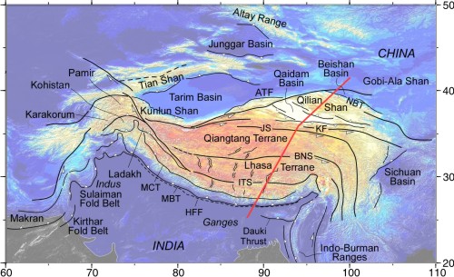
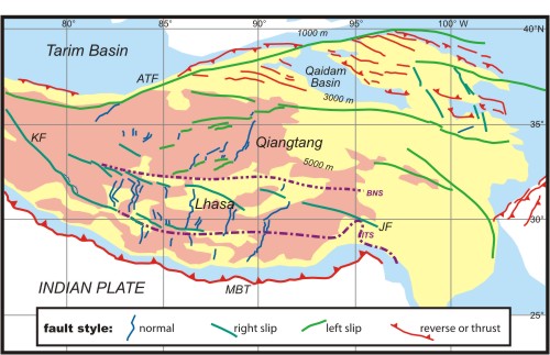
| Tectonic map, colour shades
show elevation (1000, 3000, and 5000 m contours). ATF: Altyn Tagh
Fault, MBT: Main Boundary Thrust of Himalaya, JF: Jiali Fault Zone,
KF: Karakorum Fault, ITS: Indus-Tsangpo Suture, BNS: Bangong-Nujiang
Suture.
|
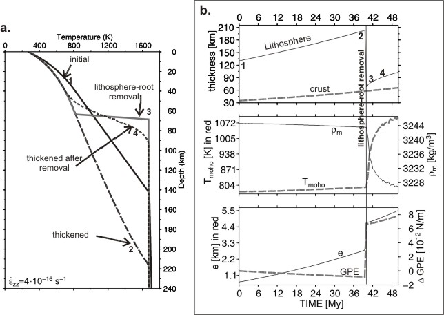
| An example of the evolution
of the geotherm before and after the removal of lithospheric mantle.
a) Time evolution of a geotherm under constant thickening and at
different stages: 1) Initial, 2) after 40 m.y. of constant thickening,
3) After removal of the lithospheric mantle, 4) 2 m.y. after the
lithospheric removal, resulting from conduction and constant thickening.
b) Time evolution of: lithosphere and crustal thickness; Moho temperature
and lithospheric mantle density; elevation and changes in gravitational
potential energy (GPE(t) - GPE(t=0)).
|


Model results after 57 m.y. of convergence at 50 mm/yr and 7 m.y.
after removal of lithospheric mantle below the 700°C isotherm
where thickness exceeds 155 km. Radiogenic heat production: H=2.5
exp(-z/15) µW/m3 and H=2.5 exp(-z/55) µW/m3 if the crust
is thicker than 40 km. a) Elevation predicted from the model (contours)
and measured (grey pattern); b) crustal thickness predicted from
the model (contours) and data (grey pattern, compiled by Bassin
et al., 2000); c) lithospheric mantle thickness predicted from the
model. |
| 
|

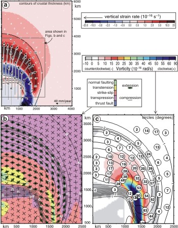
Model results after 57 m.y. of convergence at 50 mm/yr and 7 m.y.
after removal of lithospheric mantle below the 700°C isotherm
where thickness exceeds 155 km. a) Horizontal velocity field (arrows),
vertical strain rate (color pattern, positive for thickening and
negative for thinning) and crustal thickness (contours every 10
km). Grey outline is the region of the plots on Figs. b and c. b)
Horizontal principal stress directions (arrows for extension and
bars for compression), tectonic regime (color pattern) and elevation
(contours every 0.5 km). Note that this plot is a zoom on the plateau
(grey outline Fig.a). c) Vorticity (color pattern in rad/s), vertical
axis finite rotations (circled numbers in degrees) and elevation
(contours in km). This plot is also a zoom on the plateau (grey
outline Fig.a).
|
2. Lithosphere structure underneath the Tibetan Plateau inferred from elevation, gravity and geoid anomalies
(Publication: pdf)
The steep topographic gradients are also related to large lateral
variations in the geoid and gravity anomalies. In a SSW to NNE cross
section, the Bouguer gravity anomaly decreases over a distance of
500 km from about 0 mGal in the India plate to ~ -500 mGal on the
Tibetan Plateau. The geoid anomaly also presents steep gradients
on both the Himalayan front and the northern margin, reaching values
between 20-30 m on the plateau, suggesting a pronounced thinning
of the lithospheric mantle. Uplift late in the tectonic evolution
of the plateau, the widespread extension, and the associated magmatism
have been attributed to convective removal of the lower part of
lithospheric mantle and its replacement by hotter and lighter asthenosphere.
Here we present a two-dimensional lithospheric thermal and density
model along a transect from the Indian plate to Asia, crossing the
Himalaya front and the Tibetan Plateau. The model is based on the
assumption of local isostatic equilibrium, and is constrained by
the topography, gravity and geoid anomalies and by thermal data
within the crust. Our results suggest that the height of the Tibetan
Plateau is compensated by thick crust in the south and by hot upper
mantle to the north. The Tibetan Plateau as a whole cannot be supported
isostatically only by thickened crust; a thin and hot lithosphere
beneath the northern plateau is required to explain the high topography,
gravity, geoid and crustal temperatures. The lithosphere reaches
a maximum depth of ~260 km beneath the southern Plateau, and thins
abruptly northward to ~100 km under the central and northern Plateau.
The lithosphere depth increases again beneath the Qaidam basin and
the Qilian Shan to ~160 km. |
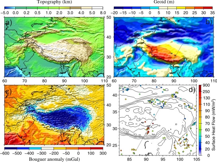
Data. a) topography; b) geoid; c) Bouguer gravity
calculated from global free air with the 3D topographic correction
[Fullea et al., submitted]; d) surface heat flow measurements from
the global data set and from the Golmud-Ejn transect between Qaidam
and Beishan basin. Grey line shows the position of the modelled
profile. Note that d) is at a larger scale than the other figures. |
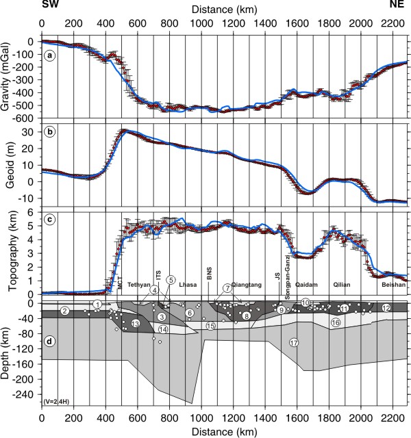
Modelling results. The top three graphs (a-c) show
data and results predicted from the model: a) Bouguer gravity anomaly,
b) geoid and c) elevation. The data are represented by dots with
bars, corresponding to the standard deviation within a range of
50 km to each side of the profile. Continuous blue lines are the
modelled values. d) Lithospheric model with a vertical exaggeration
of 2.4. The dots show earthquake hypocenters projected onto the
model from a strip 150 km wide each side of the model.. |
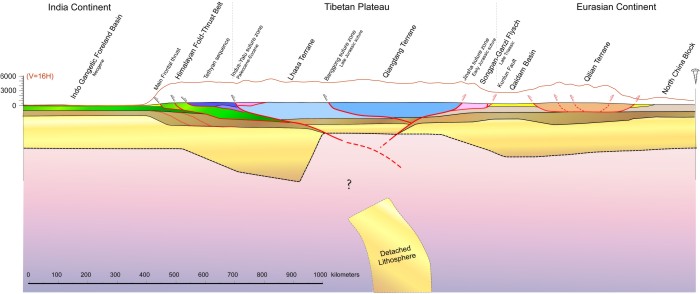
Cartoon of the resulting profile, lithosphere scale.
These results suggest that the coldest part of the mantle underlies
southern Tibet and that the hottest underlies north central Tibet.
The present average topography of the High Himalaya and Tibetan
Plateau is supported by a non-uniform crustal and lithospheric structure.
The High Himalaya and the southern Tibetan Plateau consist of thick
crust and thick upper mantle whereas the northern Tibetan Plateau
is underlain by a thinner crust and thin lithospheric mantle. |
3. Physical
modeling of the evolution of Tibet related to the present-day lithosphere
structure
work in progress
We present two different numerical modeling techniques
used to study the possible evolution of the plateau, the lithosphere-root
removal and the delamination.
We study the delamination mechanism in a vertical cross section
over the last 10 my. This work uses new algorithms of thermo-mechanical
modelling, developed in MATLAB code, able to study the temporal
evolution of the delamination. We model the evolution of a thickened
orogenic lithosphere, which brings about a Rayleigh-Taylor gravitational
instability. The motion equation and the coupled thermal equation
are solved, under the extended Boussinesq Approximation, applying
finite difference techniques. With this model we are able to reproduce
the lateral propagation of continental lithosphere delamination.
We discuss the effects of the initial geometry and the stratification
of density and viscosity required to give the present Tibetan mantle
structure.
We also investigate numerically the long-term (50 my) evolution
of crustal and lithospheric thickness, thermal structure, topography,
and strain-rate of the Tibetan plateau through time, using a planform
viscous approach. This suggests that lithospheric mantle must have
been removed from beneath Tibet, and that the crust must have been
warmed and weakened by an increase of radiogenic heat production
at depth due to crustal thickening.
Poster (pdf)
|
|