| Research Publications Projects Curriculum Links Home |
Modeling of lithospheric deformation
|
|
|
|
THIS CODE HAS BEEN USED IN: |
|
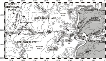
A) Neotectonic problems1. The Africa-Eurasia plate boundary from Azores to Gibraltar. (more) |
|
B) Large scale
deformation
|
|
|
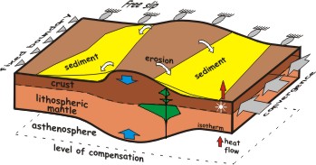
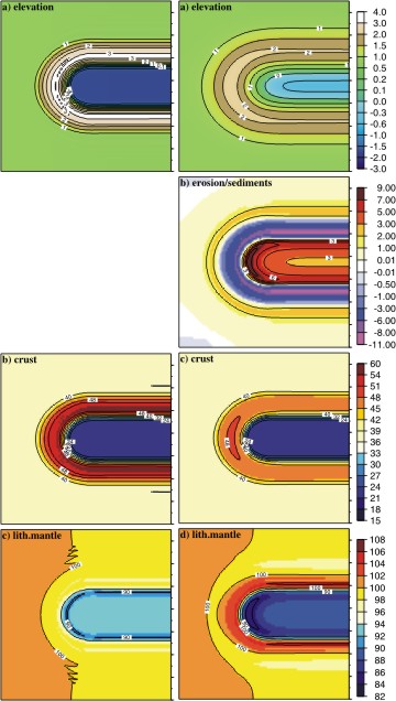
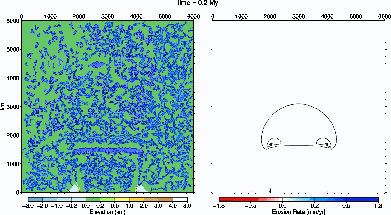
We study the effects of incorporating surface mass transport and the gravitational potential energy of both crust and lithospheric mantle to the viscous thin sheet approach. Recent 2D (cross section) numerical models show that surface erosion and sediment transport can play a major role in shaping the large-scale deformation of the crust. In order to study these effects in 3D (planform view), we develop a numerical model in which both the dynamics of lithospheric deformation and surface processes are fully coupled. Deformation is calculated as a thin viscous layer with a vertically-averaged rheology and subjected to plane stresses. The coupled system of equations for momentum and energy conservation is solved numerically. This model accounts for the isostatic and potential-energy effects due to crustal and lithospheric thickness variations. The results show that the variations of gravitational potential energy due to the lateral changes of the lithosphere-asthenosphere boundary can modify the mode of deformation of the lithosphere. Surface processes, incorporated to the model via a diffusive transport equation, rather than just passively reacting to changes in topography, play an active role in controlling the lateral variations of the effective viscosity and hence of the deformation of the lithosphere.
|
Results after 25 Myr of 10 mm/yr of convergence rate N-S. Second column incorporating erosion and sedimentation.
|
|
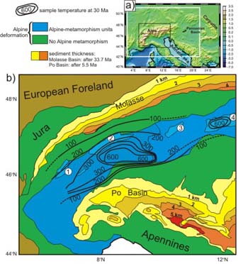
3. Gravitational and tectonic forces controlling post-collisional deformation and the present-day stress field of the Alps. |
|
|
|
(more)
|
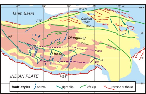
| 4. Tibetan Plateau formation. (more)
|
|
| We investigate numerically the evolution of crustal and lithospheric thickness, thermal structure, topography, and strain-rate of the Tibetan plateau through time, using the thin viscous sheet approach. We show that lithospheric mantle must have been removed from beneath Tibet to explain the present surface elevation and lack of regional surface slope. In the absence of this removal, the modelled topography reaches a maximum elevation of <4000 m (for weak rheology), or the surface slopes significantly northwards (for strong rheology). The crust must have been warmed and weakened by an increase of radiogenic heat production at depth due to crustal thickening. In the absence of this warming, viscous stresses associated with plate convergence exceed stresses produced by topography, and the present pattern of vertical thinning and east-west extension would not have developed. Continuous removal of lithosphere, by delamination or convection, does not allow sufficient crustal warming, and fails to reproduce either the present topography or the pattern of active deformation on the plateau in a reasonable time. Geologically rapid removal of the lithospheric root beneath the thickened crust of Tibet successfully explains the current elevation of the plateau, its lack of surface slope, the steep south and north margins, and the pattern of the present deformation, including vertical thinning, E-W extension, and extrusion and vertical axis rotation on the eastern margin. Our modelling suggests that this removal took place within the last 12 m.y.
|
|
| 5. UhuruTISC. Topographic Evolution and Climate Aridification during Continental Collision
code develope with Daniel Garcia-Castellanos |
|
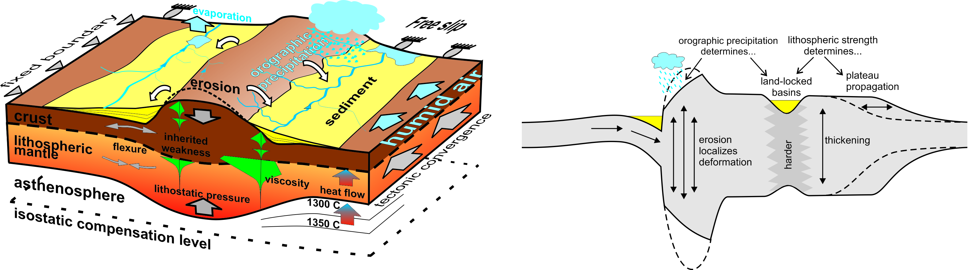
| How do the feedbacks between tectonics, sediment transport and climate work to shape the topographic evolution of the Earth? This question has been widely addressed via numerical models constrained with thermochronological and geomorphological data at scales ranging from local to orogenic. Here we present a novel numerical model that aims at reproducing the interaction between these processes at the continental scale. For this purpose, we com- bine in a single computer program: 1) a thin-sheet viscous model of continental deformation; 2) a stream-power surface-transport approach; 3) flexural isostasy allowing for the forma- tion of large sedimentary foreland basins; and 4) an orographic precipitation model that reproduces basic climatic effects such as continentality and rain shadow. We quantify the feedbacks between these processes in a synthetic scenario inspired by the India-Asia colli- sion and the growth of the Tibetan Plateau. We identify a feedback between erosion and crustal thickening leading locally to a minus 50% increase in deformation rates in places where orographic precipitation is concentrated. This climatically-enhanced deformation takes place preferentially at the upwind flank of the growing plateau, specially at the corners of the indenter (syntaxes). We hypothesize that this may provide clues for better understanding the mechanisms underlying the intriguing tectonic aneurisms documented in the Himalayas. At the continental scale, however, the overall distribution of topographic basins and ranges seems insensitive to climatic factors, despite these do have important, sometimes counter- intuitive effects on the amount of sediments trapped within the continent. The dry climatic conditions that naturally develop in the interior of the continent, for example, trigger large intra-continental sediment trapping at basins similar to the Tarim Basin because they deter- mine its endorheic/exorheic drainage. These complex climatic-drainage-tectonic interac- tions make the development of steady-state topography at the continental scale unlikely.
|
|
| |
|